Been up here several times. First time I got to see wildlife on top of the tower.
One of the most popular day hikes in the Black Hills is the hike up to Black Elk Peak (formerly known as Harney Peak). This hike will take you through the Black Elk Wilderness area where bicycles, motorized vehicles, and even motorized equipment are prohibited. At 7,242 feet it is the highest point in South Dakota and also the highest point east of the Rockies in the United States. On top of the peak stands the peak's most recognizable feature, an old out of service Fire Lookout Tower. The tower, which was used in the 1930s, can be seen from miles away. So if your not sure if you're looking at Black Elk Peak, just look for the fire tower at the top.
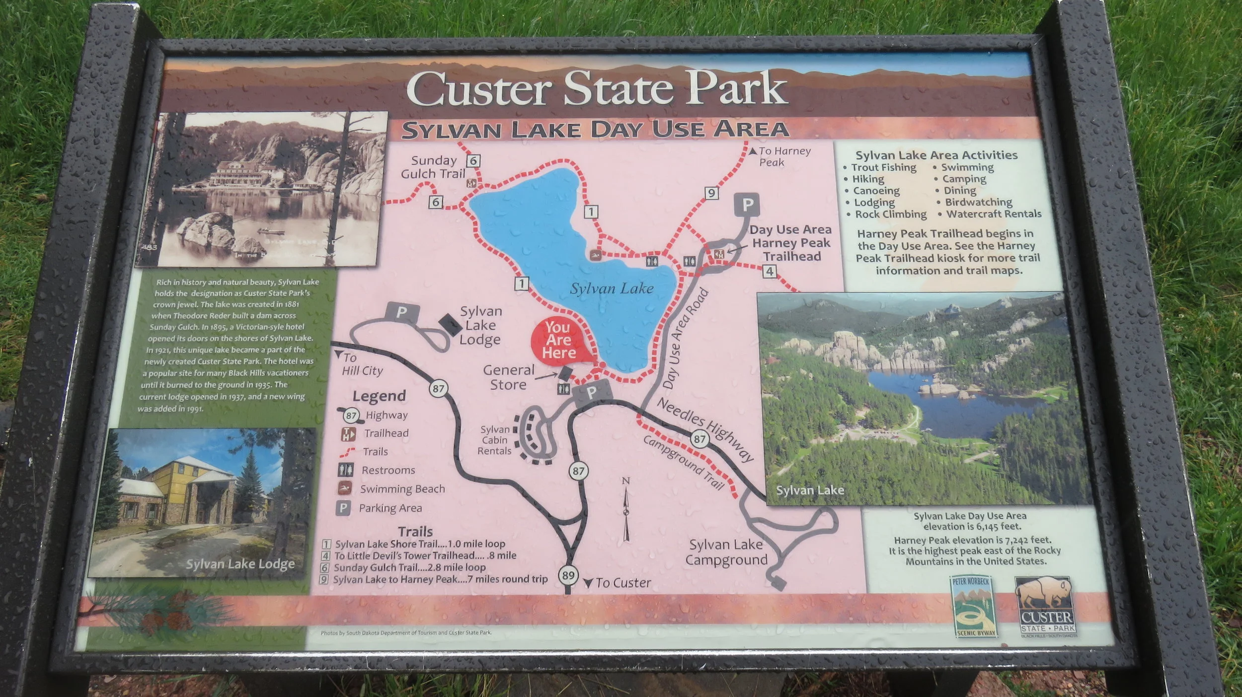
There are several trails that will take you to the peak but no matter which trail you take there will be strenuous sections with the steepest part being the last half mile or so before you reach the top. The most popular trail is Trail #9S, with the S standing for South. The trail has easy access, beginning on the northeast side of Sylvan Lake, and is about 3.8 miles long (One way) with an elevation gain of about 1100 ft.. On the way you'll pass by Little Devil's Tower (although you won't have access to it) as well as spacious views of the Black Hills. The Trail is easy to follow but remember it is a popular trail, so if your looking for solitude, you might want to pick a different trail unless you're going in the off season.
One of my favorite trails is Trail #4. You can either leave from the Sylvan Lake Trail Head or the Little Devils Tower Trail Head. If you leave from the Little Devils Tower TH, it will be about 4 miles to the summit with an 1100 ft. elevation gain. Hiking this direction lets you take a short detour to Little Devil's Tower, where you have easy access to the top of the tower and great views of Black Elk Peak and the Cathedral Spires. About two thirds of the way to the top Trail #4 merges with Trail #3 for the remainder of the hike.
Probably the shortest route is to start at the Cathedral Spires Trail Head. It's around 3 1/2 miles to the summit with the same elevation gain as the previous 2 trails although a little more complicated than the other 2. You take the Cathedral Spires trail until you reach a spur trail that will meet up with Trail #4 which eventually merges with Trail #3 until you reach the summit. Besides being shorter, this trail takes you through the Cathedral Spires, past Little Devils Tower, and up to Black Elk Peak.
The next trail is #9N which starts at the Willow Creek Trail Head off of HIghway 244 just west of Mount Rushmore. This trail approaches the peak from the north and is 4.7 miles to the top. Besides being longer, the other drawback for hikers using this trail is that it does get a lot of horse travel on it making it a rougher trail with the occasional horse droppings. This trail is pretty hard and goes straight up, but the views along the way are gorgeous and well worth it. Out of tourist season, you will probably not see a soul on this trail. This trail was a treat when we hiked it - I was pleasantly surprised at how amazing it was and all the different landscapes we came across.
All the trails mentioned above are straightforward and easy to follow but if you're looking for a longer hike you can link a number of trails together to get to the peak, just check the trail systems map that I've uploaded below and map out your own route. Whichever route you choose, the payoff will be worth it. From the top of Black Elk peak you'll see the Badlands off to the east, Terry Peak to the northwest, the cathedral spires below, and the wide open sky above. If you're looking for a great day hike in the Hills, this one is hard to beat.
At the top of Black Elk.
Black Elk Peak fire tower.
I've also included below, a track of one of our hikes where we went up to the peak starting at the Little Devils Tower TH and then going down using trial #9S. For more information check out the individual hikes under Regional Adventures/Custer State Park.


